محتوای الکترونیکی
Chorleywood is a village near London whose population has increased steadily – Map

You should write at least 150 words.
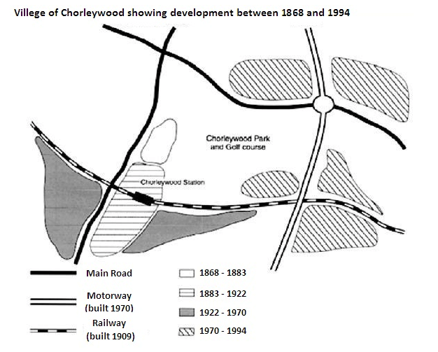
Chorleywood is a village near London whose population has increased steadily since the middle of the 19th century. The map below shows the development of the village.
Write a report for a university lecturer describing the development of the village.
You should spend about 20 minutes on this task.

Sample Answer
| The illustration shows how a village, named Chorleywood in London had developed from 1868 to 1994. Generally, a much rapid development has been seen in the rural area from 1970 to 1994 than previous decades. As the graph showcases, the improvements in the 19th century were limited when the surrounding area of the Chorleywood station saw development. The introduction of railways came in 1909 and it went around the station area to develop a ground for extensive construction and development between 1922 and 1970. During the end of this period, the establishment of motorways was done in the village. The village saw rapid development between the time period of 1970 and 1994. At this time, it had a wider roadway. It is also worth noticing how the construction and development in Chorleywood were guided by the facilities of transportation as the area of junction saw a large-scale, faster progress than others. Also, the motorways and road formed a (#) hash-like road system in the village. |
2 نظر
The provided map illustrates the transformation of a village called Chorleywood from 1868 to 1994. Overall, the most noticeable changes was made to the east of this district from 1970 to 1994. At the beginning of the period Chorleywood was a tiny village situated to the west part of the park; moreover, there was a main road that traverses this area from north to south as well as east west. In the second period, regarding the infrastructure, railway was set up which crossed this area from east to west. Chorleywood station was built to the south of the old region, where new residential area was expanded around the station. From 1922 to 1970, two new accommodation areas were constructed along the railway to the east and west side of main road; in addition, motorway had been built on the eastern part by 1970, which ran south to north. In the last period, new inhabited regions were erected at the intersection of motorway withA both railway and main road.
The map illustrates the expansion of a village that is called Chorleywood from 1868 to 1994. It is clear that this region of the village has undergone huge changes as the transport infrastructure was improved. Four periods of development are shown on the map, and there were a lot of population densities near to the main roads, the railway or the motorway. As can be seen from 1868 to 1883, there was a small area of Chorleywood next to one of the main roads, after that between 1883 and 1922, this village grew along the main road to the South, also in 1909, railway line was erected from West to East. Furthermore, Chorleywood station, Golf course and park were in that part of the village. The growth of Chorleywood continued to the East and West between 1922 and 1970. At that time, one motorway was put up from the North to the South, Ultimately, Chorleywood was enlarged all around the railway, main road and motorway, also the most of the change in this village took place between 1970 and 1994.
لطفا وارد شوید و نظر خود را ثبت نمایید.
بهترین ها
| نام | تعداد آزمون | میزان موفقیت | |
|---|---|---|---|
| َAmeneh Darvishzadeh | 1 | 100/00 % | |
| Mehrad Hashemi | 1 | 100/00 % | |
| مهدی حسین پور آقائی | 1 | 100/00 % | |
| Farnoush Toghiany | 21 | 98/36 % | |
| zahra namdari | 46 | 98/21 % | |
| یاسمن محمدی پور | 4 | 98/08 % | |
| Sheida Taheri | 3 | 97/37 % | |
| پژمان همدانی | 3 | 97/37 % | |
| محمدحسین میرزایی | 3 | 97/30 % | |
| Tara Mohammadi | 3 | 96/43 % | |
| yasaman mohamadipur | 51 | 95/86 % | |
| محمدجواد ملائی اردستانی | 3 | 94/44 % | |
| Arzhang Saberi | 4 | 93/33 % | |
| Soheila Karimi | 124 | 92/73 % | |
| aram farhmand | 10 | 92/31 % | |
| یاشار اسکندری | 98 | 91/14 % | |
| الشان مقیمی آذر | 11 | 90/80 % | |
| عباس پورمیدانی | 1 | 90/00 % | |
| پریسا سلوکی شهرضایی | 72 | 89/49 % | |
| ارشیا قلمکاری | 33 | 89/23 % |


