محتوای الکترونیکی
Hawaiian island chain in the centre of the Pacific Ocean – Map

You should spend about 20 minutes on this task.
Write at least 150 words.
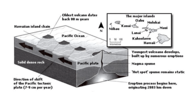
The diagram below gives information about the Hawaiian island chain in the centre of the Pacific Ocean.
Write a report for a university lecturer describing the information shown.
Sample Answer
| The map represents the Hawaiian island chain, it is located in the heart of the Pacific Ocean. As shown, it is formed of volcanoes and the active volcanoes are located at the south-east tip, where Hawaii is located. It also shows how the volcano eruption occurs. It is shown that the chain began to form almost 80 million years ago on the solid dense rock bed and each island started to evolve after an eruption on the seafloor. A hot spot existed on the ocean bed, which let out the material which is known as the magma. Moreover, the hot spot remained static. Hence, magma spume was formed and this magma originated from as deep as 2,883 km below the ocean bed. Eruptions took place and a volcano was formed above the surface of the ocean. Later, the spume of magma has remained inactive as the Pacific tectonic plate moves in a north-west direction across it, at an annual speed of 7-9 centimetre. The other major islands in the Pacific ocean are Niihau, Kauai, Oahu, Molokai, Maui, Lanai and Kahoolawe which are located from 0-100 kilometres away from each other. |
6 نظر
The Hawaiian island is the largest among the eight islands of the Pacific Ocean, with some tiny islands such as Nihau also being found in the Ocean. The Pacific Ocean experiences tectonic plate movement drifting apart around 7 to 9cm each year. This has resulted in many volcanoes being formed in one of the major islands, the Hawaiian Islands. As illustrated in the diagram, Hawaiian Island had suffered major volcanic eruptions, with the oldest dating back some 80million years ago. The volcanic eruption process begins to form some 2883km below the solid, dense rock. Eventually, a spume is formed, which remains immobile on the Hot spot. Until tectonic plates drift to the north-western angle of the ocean some 7 to 9 centimeters, magma spume flows through the solid, dense rock, initiating another volcanic activity.
The provided diagram illustrates how Hawaiian chain has been formed. Overall, Hawaiian Island is by far the largest island surrounded by quite a few tiny isles such as Kahoolawe, which is the nearest neighbor for Hawaii Island Oldest volcano dates rose out of the Pacific Ocean about 80 years ago. As is observed, the eruption process originates from 2883 km depth of the ocean surface. Pacific plate tend to further move to the north-east side of the Hawaiian island, whereas hot spot spume, which comes from deep sea, remain immobile during the aforementioned movement of the plate. This transfer leads to the discharging of magma spume into surface of the Pacific Ocean, subsequently the youngest volcano has been formed to the south eastern part of this area. The Youngest volcano causes numerous eruption, on the contrary, the oldest one seems to be inactive.
The diagram illustrates information on the Hawaiian island chain which is located in the heart of the Pacific Ocean. It is clear that these islands are formed of volcanoes and the active islands are at the south-east tip of the Pacific Ocean, where Hawaii itself is situated. It also shows that how the volcano eruption occurs. As can be seen, the oldest volcano dates back 80 million years ago that they were built by numerous eruptions on the solid dense rock, after that they were constructed as island such as Hawaiian island chain. In the face of eruption process which they originated from 2883 kilometers down. Hence there is a hot spot which it remains static that it leads to erupt substances that is called Magma spume. It is obvious that annual speed of the Pacific tectonic plate is 7 to 9 centimeters. On top of that the direction of shift of them is toward south-east. Moreover, the other major islands in the Pacific Ocean are Niihau, Kauai, Oahu, Molokai, Maui, Lanai, and Kahoolawe which are put in 0 to 100 kilometers away from each other.
According to this map, the Hawaiian Archipelago is located at the south east of Pacific ocean. From an overall perspective, we can perceive the ways of formation of this islands as well as how active volcanoes erupt. From a closer inspection of the map, about 80 millions years ago, eruption process originated from a depth of 2,883 km below the ocean bed. So a hot spot was created in the ocean that spewed material called "Magma". A numerous of these eruptive processes caused the creation and development of a volcano that each island started to evolve after an eruption on the seafloor. On the other hand, the hot spot remained static, forming magma spume and remaining inactive as the Pacific tectonic plate moved in a northwesterly direction across it at a rate of 7-9 cm per year. The other major islands created in the Pacific Ocean are Niihau, Kauai, Oahu, Molokai, Maui, Lanai, and Kahului, which are within 0 to 100 km of each other.
According to this map, the Hawaiian Archipelago is located at the south east of Pacific ocean. From an overall perspective, we can perceive the ways of formation of this islands as well as how active volcanoes erupt. From a closer inspection of the map, about 80 millions years ago, eruption process originated from a depth of 2,883 km below the ocean bed. So a hot spot was created in the ocean that spewed material called "Magma". A numerous of these eruptive processes caused the creation and development of a volcano that each island started to evolve after an eruption on the seafloor. On the other hand, the hot spot remained static, forming magma spume. The spume magma was remaining inactive, as the Pacific tectonic plate moved in a northwesterly direction across it, at a rate of 7-9 cm per year. The other major islands created in the Pacific Ocean are Niihau, Kauai, Oahu, Molokai, Maui, Lanai, and Kahului, which are within 0 to 100 km of each other.
The given diagram illustrate the process of orogeny in Hawaiian island chain, located in the middle of pacific ocean. Hawaiian archipelago are formed by numerous eruptions during millions of years. The major island that presented in diagram are Niihau, Kauai, oahu, Molokai, lanai, maui, kahoolawe and the main island, Hawaii wich located South-East of other lands. Actually Hawaiian island chain are plenty of volcanoes that formed on in the solid dense rock bed in the bed of ocean and each one rises from the water shaped an island. Oldest volcano erupts about 80 million years ago and this orogeny continues with the eruptions of new volcanoes. Euroption process wich placed 2883 km downer than pacific tactonic plate pushed the static magma to the ocean floor and as soon as lava hits the water the a volcano birth in deep waters. This process shifts pacific tactonic plate 7-9 cm per year.
لطفا وارد شوید و نظر خود را ثبت نمایید.
بهترین ها
| نام | تعداد آزمون | میزان موفقیت | |
|---|---|---|---|
| َAmeneh Darvishzadeh | 1 | 100/00 % | |
| Mehrad Hashemi | 1 | 100/00 % | |
| مهدی حسین پور آقائی | 1 | 100/00 % | |
| Farnoush Toghiany | 21 | 98/36 % | |
| zahra namdari | 46 | 98/21 % | |
| یاسمن محمدی پور | 4 | 98/08 % | |
| Sheida Taheri | 3 | 97/37 % | |
| پژمان همدانی | 3 | 97/37 % | |
| محمدحسین میرزایی | 3 | 97/30 % | |
| Tara Mohammadi | 3 | 96/43 % | |
| yasaman mohamadipur | 51 | 95/86 % | |
| محمدجواد ملائی اردستانی | 3 | 94/44 % | |
| Arzhang Saberi | 4 | 93/33 % | |
| Soheila Karimi | 124 | 92/73 % | |
| aram farhmand | 10 | 92/31 % | |
| یاشار اسکندری | 98 | 91/14 % | |
| الشان مقیمی آذر | 11 | 90/80 % | |
| عباس پورمیدانی | 1 | 90/00 % | |
| پریسا سلوکی شهرضایی | 72 | 89/49 % | |
| ارشیا قلمکاری | 33 | 89/23 % |