محتوای الکترونیکی
Two possible sites for the supermarket – Map

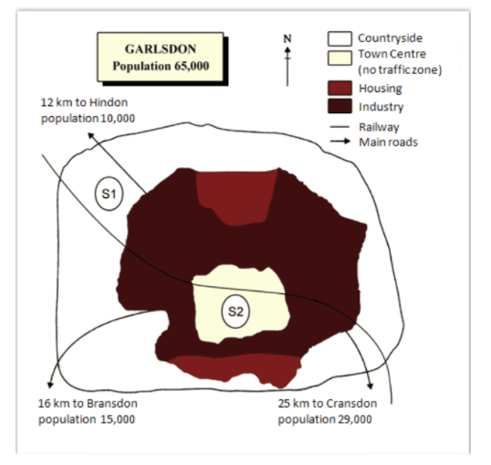
The map below is of the town of Garlsdon. A new supermarket (S) is planned for the town. The map shows two possible sites for the supermarket.
Summarise the information by selecting and reporting the main features, and make comparisons where relevant.
You should write at least 150 words.
Sample Answer
| The map displays two locations for the construction of a supermarket in Garlsdon. As indicated in the map, the city has a population of 65,000. From an overall perspective, we find that the locations identified for the supermarket are in the countryside near Hindon and the town centre near to Bransdon and Cransdon. From a closer inspection of the map, it is evident that the first site in the north-west, located near Hindon which has a population of 10,000 would be away from the industrial and housing areas. However, it is well-connected to these areas by road and rail. But we have to consider the fact that though it is in close proximity to Hindon, it is quite far away from Bransdon and Cransdon which are densely populated. The second site is located at the heart of the city and is surrounded by industrial areas. It is 16km from Bransdon and 25 km from Cransdon. It is connected to Hindon and Cransdon by road and rail whereas people of Bransdon can only use the road. |
6 نظر
The map shows two potential locations for a new supermarket in a town named Garsldon. Although the sites can be compared in terms of access by rail or road, the most significant difference between them is that S1 is outside town and S2 is in the town center. Their position relative to three smaller town can also be discussed. Looking at the information in more detail, S1 is in the countryside to the south west Garlsdon, but it is close to the residential area of the town which has a population of 10,000. S2 is also close to the housing area which surrounds the town center. It is 16 km to Bronsdon and 25 km to Cransdon. There are main roads from Brandson, Crandson and Hindon To garlsdon town center, but this is a no traffic zone. So there is no access to S2 by car. By contrast, S1 has access to the Hindone by main road. Both supermarket sites are close to the railway that runs through Garlsdon from Hindone to Carnsdon.
The map compares two potential locations for the building of a new supermarket in a town called Garlsdon. As indicated in the map, the city has a population of 65,000. The main difference between the two sites is that one is located in the countryside outside the town, whereas the other is in the town center. Both potential sites are close to the railway, and reasonably near to the main road. The first possible site for the supermarket (S1) is located in an area of countryside to the northwest of Garlsdon. It is close to the railway line and to the main road connecting Garlsdon to the smaller town of Hindon. It is also situated near the residential housing area of Garlsdon. The second site (S2), by contrast, is located at the heart of the city and is surrounded by industrial areas. It is 16km from Bransdon and 25 km from Cransdon. It is connected to Hindon and Cransdon by road and rail whereas people of Bransdon can only use the road.
The map shows two suggested locations for a new supermarket in the Gersldon city. It is clear that the first site is on countryside, which both railway and main roads pass near it, while the second site is located in town center where rail way is only accessible. The both sites can also be compared in terms of their distances to other cities. The first location for supermarket located approximately to the north west of area besides, it is 12 km far away from another city called Hindon which is less populated than Garlsdon. Moreover, it has easy access to railway and main roads. The second suggestion is in the middle of the accommodations of people in the town center, which is almost close to one part of industries district. Although, this site do not have a main road around, which is the reason of no traffic congestion, two other smaller cities Bransdon and Grandon that are 16 km and 25 km away respectively have easy access to this site.
The map illustrate two sites for a supermarket in Garlsdon that be planned to be built. As indicated in the map, the population of the city is about 65,000. From an overall perspective, considering that everyone should have access to it, therefore, we will scrutiny two the locations identified in the countryside and the town center. From a closer inspection of the map, it is evident that the first site in the north-west of Garlsdon is near the Hindon with 10,000 population, which would be away from the industrial and residential areas. It will be well-connected for this area by rail and road, but not for other parts of the city. Because this place is quite far away from Bransdon and Cransdon which are densely populated. The second site is bestead in the heart of the city, surrounded by industrial areas. It is 16 km from Bransdon and 25 km from Cransdon, connected to Hendon and Cransdon by road and rail while the people of Brandon can only use the road.
This map shows two sites for a supermarket in Garlsdon which is to be built. As shown in the map, the total population of this city is 65,000 people. In general, considering that the entire population should have access to the supermarket, we examine two selected locations. Regarding the first place, which is in the suburbs and outside the industrial and residential area, it is the closest place to Hindon city, which is accessible by both train and road, but it is quite far from the two cities of Bransdon and Cransdon. When it comes to the second location, it is the best location as it is located in the center of the city, as well as having access to the two towns of Hindon and Cransdon by road and rail and Bransdon by road.
The given map illustrate the Garlsdon city area and two possible site which considered for supermarket(s) location. The Garlsdon has a population of 65000 and surrounded by 3 smaller towns. Hindon with a population of 10000 located 12km of North-West and Bransdon and Cransdon with a population of 15 and 29 thousand placed in 16km of South-West and 25km of South-East, respectively. All these towns have a road accses to Galsdon but the railway is just stretched from the South-East to the North-West and by passing through the Gardson town center, connect Hinddon and Cransdon to each other. First site which deliberated for supermarket placed on the North-East between the rail way and main road to the Hindon town.on the other second site considered at the heart of Garlsdon in town center which has an almost equal path from housing area in north and south side of the town and industry zone that covers town center. Site 2 seams to be better choose in each logical way, because, although that it located in no traffic zone in the town center, but, the middle of the town provides wider access for all Garlsdon townsfolk and suburban towns. (196 words)
لطفا وارد شوید و نظر خود را ثبت نمایید.
بهترین ها
| نام | تعداد آزمون | میزان موفقیت | |
|---|---|---|---|
| َAmeneh Darvishzadeh | 1 | 100/00 % | |
| Mehrad Hashemi | 1 | 100/00 % | |
| مهدی حسین پور آقائی | 1 | 100/00 % | |
| Farnoush Toghiany | 21 | 98/36 % | |
| zahra namdari | 46 | 98/21 % | |
| یاسمن محمدی پور | 4 | 98/08 % | |
| Sheida Taheri | 3 | 97/37 % | |
| پژمان همدانی | 3 | 97/37 % | |
| محمدحسین میرزایی | 3 | 97/30 % | |
| Tara Mohammadi | 3 | 96/43 % | |
| yasaman mohamadipur | 51 | 95/86 % | |
| محمدجواد ملائی اردستانی | 3 | 94/44 % | |
| Arzhang Saberi | 4 | 93/33 % | |
| Soheila Karimi | 124 | 92/73 % | |
| aram farhmand | 10 | 92/31 % | |
| یاشار اسکندری | 98 | 91/14 % | |
| الشان مقیمی آذر | 11 | 90/80 % | |
| عباس پورمیدانی | 1 | 90/00 % | |
| پریسا سلوکی شهرضایی | 72 | 89/49 % | |
| ارشیا قلمکاری | 33 | 89/23 % |